Google Maps Adds Mumbai Floods Feature To Alert Waterlogged Roads & Road Closures

An annual event now, the city of Mumbai finds itself coming to a halt every time the rain gods are a little more generous than usual. The city's crumbling infrastructure can barely handle its population, it certainly does not have space to accommodate more water or the means to channelise it efficiently into the Arabian sea. In the recent spell of showers, the city reportedy one of its highest rainfalls at 375.2 mm since 2005 that not only flooded most of the low lying areas but also disrupted public transport services and the roads. For those commuting then, it is imperative to know which areas are flooded and which aren't in Mumbai. To make things easier, Google Maps has been updated with a new feature that allows users to check for waterlogged areas and look for alternate routes instead.
Also Read: Google Maps Get 'Stay Safer' Feature On Android Phones In India
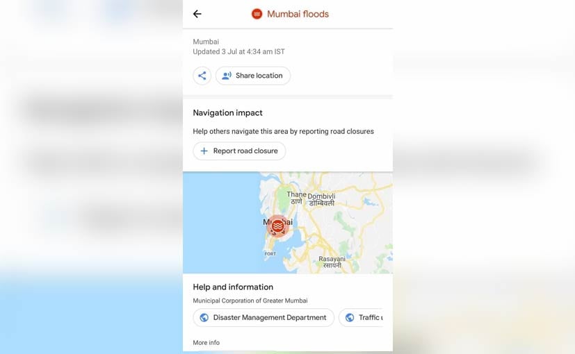
The waterlogged areas and road closures are updated by users for realtime details
The Mumbai Floods feature on Google Maps operates on user data and allows users to report of water logged sections and closed roads across the city. The app users can select from a number of reasons for reporting road closure including a crash, roadworks, local event, nature or any other reason. You have to also select the exact location along with other relevant details like the date and time as well as the direction of traffic flow to update the system. The area will then be marked on Google Maps with the data helping other road users to navigate with ease.
Also Read: Google Maps Now Displays Speed Cameras In India
The Mumbai Floods update is available on both Android OS and iOS devices. Earlier this year, the tech giant also introduced new features on Google Maps for India including identifying speed cameras on public roads that definitely helps in not getting a speeding fine. More recently, the Stay Safer feature was added that allows you to inform friends and family on your live location, route and cab details. The latter though is only offered on Android devices for now.
Related News


Latest Cars


Upcoming Cars


Latest News
 car&bike Team | Jul 3, 2026Yamaha R2 India Launch Expected in August 2026Like the Yamaha R15, the new R2 will be developed and manufactured in India and is expected to be powered by a 200 cc single-cylinder engine.1 min read
 Carandbike Team | Jul 3, 2026Tata Sierra ICE vs EV: What Are The Differences & Similarities?If you are looking to compare the Tata Sierra ICE and the newly launched Sierra EV in terms of design, features, powertrains, safety, pricing and key differences, look no further, as here’s everything you need to know about the two.1 min read
 car&bike Team | Jul 3, 2026Renault Kwid Prices Slashed: Fully-Loaded Climber MT Now Costs Rs 5 LakhRenault has updated the Kwid with a simpler two-variant line-up, revised prices and subtle styling tweaks.1 min read
 Amaan Ahmed | Jul 3, 2026Keeway Hypevolt-R Launched In India At Rs 1.99 Lakh: 5 kWh Battery, 14-Inch Wheels, ABS And MoreKeeway's first electric scooter for India also packs a rear camera and blind spot detection; undercuts the TVS X and is priced nearly on par with Ather's 450 Apex.2 mins read
 car&bike Team | Jul 2, 2026Maruti Suzuki Inaugurates New Kharkhoda Plant; Production Capacity To Reach 10 Lakh Cars A YearMaruti Suzuki has inaugurated its new Kharkhoda manufacturing facility in Haryana, which starts with an annual capacity of 5 lakh vehicles and is spread across 800 acres.1 min read
 car&bike Team | Jul 2, 2026Yezdi Scrambler To Be Available On Amazon From July 4The Yezdi Scrambler will go on sale on Amazon as part of the e-commerce giant's Prime Day 2026.2 mins read
 Seshan Vijayraghvan | Jun 29, 2026Renault Kiger vs Toyota Urban Cruiser Taisor: Which Underdog Deserves Your Money?Both the Kiger and the Taisor promise strong performance, solid features, comfortable cabins and everyday usability, all without breaking the bank. But which of these underrated subcompact SUVs deserves your money? Let's find out.1 min read
 Seshan Vijayraghvan | Jun 29, 2026Skoda Kodiaq RS Review: The Best Kodiaq Yet?The Skoda Kodiaq RS is finally here, and it's every bit as exciting as I expected. But was it worth the wait?7 mins read
 Bilal Firfiray | Jun 28, 2026BMW X6 M60i Review: It’s Back And HOW!The BMW X6 M60i blends a 530bhp twin-turbo V8, with its unmistakable coupe-SUV styling. There’s plenty of character, but is it worth your money?6 mins read
 Janak Sorap | Jun 25, 2026350cc Bajaj Dominar 400 Review: Same Character, Lower PriceA slightly lower displacement engine, a significantly lower price tag and nearly the same performance — the Bajaj Dominar 400 aims to be smarter rather than faster.6 mins read
 Preetam Bora | Jun 25, 20262026 Bajaj Pulsar NS400Z First Ride Review: Smaller Engine, But Should You Buy It?The Bajaj Pulsar NS400Z won our Two-Wheeler Upgrade of the Year. Then new tax slabs happened. Smaller engine, same badge – but does it still deliver?6 mins read